搜索结果: 1-15 共查到“摄影测量与遥感技术 Camera”相关记录209条 . 查询时间(0.093 秒)

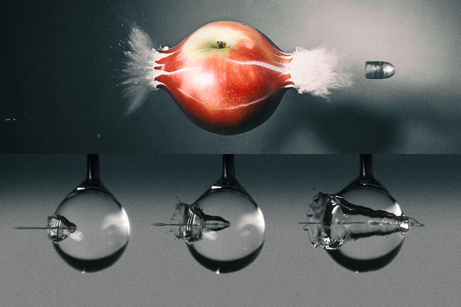
High-speed camera captures a water jet’s splashy impact as it pierces a droplet(图)
高速摄像机 水射流 注射药物
2021/8/18
STUDY ON THE INFLUENCE OF CCD DETECTOR TEMPERATURE ON THE PERFORMANCE OF THE SPACE REMOTE SENSING CAMERA
Remote Sensing Camera Charge-coupled Device Temperature Signal-to-Noise Ratio Dynamic Range
2018/4/30
The CCD detector is the core device of the space remote sensing camera. The performance of CCD detector greatly affects the performance of the whole remote sensing camera. The temperature of the CCD d...
FISHEYE MULTI-CAMERA SYSTEM CALIBRATION FOR SURVEYING NARROW AND COMPLEX ARCHITECTURES
Fisheye Photogrammetry Multi-camera Calibration Accuracy Cultural Heritage Survey Narrow Spaces
2018/3/30
Narrow spaces and passages are not a rare encounter in cultural heritage, the shape and extension of those areas place a serious challenge on any techniques one may choose to survey their 3D geometry....
PROTOTYPIC DEVELOPMENT AND EVALUATION OF A MEDIUM FORMAT METRIC CAMERA
photogrammetry accuracy metric camera calibration length measurement error large volume metrology
2018/3/30
Engineering applications require high-precision 3D measurement techniques for object sizes that vary between small volumes (2–3 m in each direction) and large volumes (around 20 x 20...
POSSIBILITIES OF PROCESSING ARCHIVAL PHOTOGRAMMETRIC IMAGES CAPTURED BY ROLLEI 6006 METRIC CAMERA USING CURRENT METHOD
Rollei 6006 metric Photo negatives Structure from motion Archival data Close range photogrammetry
2018/3/30
Processing of analog photogrammetric negatives using current methods brings new challenges and possibilities, for example, creation of a 3D model from archival images which enables the comparison of h...
PRELIMINARY EVALUATION OF A COMMERCIAL 360 MULTI-CAMERA RIG FOR PHOTOGRAMMETRIC PURPOSES
Calibration 360 Images Multi-Camera system Cultural Heritage Photogrammetry
2018/3/30
The research presented in this paper is focused on a preliminary evaluation of a 360 multi-camera rig: the possibilities to use the images acquired by the system in a photogrammetric workflow and for ...
DTM GENERATION THROUGH UAV SURVEY WITH A FISHEYE CAMERA ON A VINEYARD
UAV Precision Agriculture Fisheye DTM Kriging interpolation Vegetation
2018/3/30
Precision agriculture recommends a sustainable employment of nutrients and water, according to the site-specific crop requirements. In this context, the knowledge of soil characteristics allows to app...
STRUCTURE-FROM-MOTION FOR CALIBRATION OF A VEHICLE CAMERA SYSTEM WITH NON-OVERLAPPING FIELDS-OF-VIEW IN AN URBAN ENVIRONMENT
Vehicle cameras camera calibration structure from motion bundle adjustment
2017/5/31
Vehicle environment cameras observing traffic participants in the area around a car and interior cameras observing the car driver are important data sources for driver intention recognition algorithms...
STUDY OF THE INTEGRATION OF LIDAR AND PHOTOGRAMMETRIC DATASETS BY IN SITU CAMERA CALIBRATION AND INTEGRATED SENSOR ORIENTATION
Integrated Sensor Orientation Direct Sensor Orientation In situ Calibration Photogrammetry Lidar
2017/5/31
Photogrammetric and Lidar datasets should be in the same mapping or geodetic frame to be used simultaneously in an engineering project. Nowadays direct sensor orientation is a common procedure used in...
SHUTTER-LESS TEMPERATURE-DEPENDENT CORRECTION FOR UNCOOLED THERMAL CAMERA UNDER FAST CHANGING FPA TEMPERATURE
Uncooled Thermal Camera Fast Changing FPA Temperature Shutter-less Temperature-dependent Correction Radiometric Calibration FLIR GEV
2017/5/31
Conventional temperature-dependant correction methods for uncooled cameras are not so valid for images under the condition of fast changing FPA temperature as usual, therefore, a shutter-less temperat...
RELATIVE CAMERA POSE ESTIMATION METHOD USING OPTIMIZATION ON THE MANIFOLD
Pose Estimation Optimization Manifold Lie Group/Algebra Levenberg-Marquardt
2017/5/30
To solve the problem of relative camera pose estimation, a method using optimization with respect to the manifold is proposed. Firstly from maximum-a-posteriori (MAP) model to nonlinear least squares ...
3D MODELLING OF ARCHAEOLOGICAL SMALL FINDS BY A LOW-COST RANGE CAMERA: METHODOLOGY AND FIRST RESULTS
Close range photogrammetry 3D modelling Range Cameras Structure Sensor Small Finds
2017/5/20
The production of reliable documentation of small finds is a crucial process during archaeological excavations. Range cameras can be a valid alternative to traditional illustration methods: they are v...
A unique camera that can capture a detailed micron-resolution image from a distance uses a laser and techniques that borrow from holography, microscopy and “Matrix”-style bullet time. A prototype buil...
CAMERA CALIBRATION ACCURACY AT DIFFERENT UAV FLYING HEIGHTS
Camera calibration accuracy assessment object distances UAV flying heights
2017/2/6
Unmanned Aerial Vehicles (UAVs) can be used to acquire highly accurate data in deformation survey, whereby low-cost digital cameras are commonly used in the UAV mapping. Thus, camera calibration is co...
Development of Open source-based automatic shooting and processing UAV imagery for Orthoimage Using Smart Camera UAV
Smart Camera UAV Open source Automatic shooting Open Drone Map (ODM)
2016/11/24
Recently, aerial photography with unmanned aerial vehicle (UAV) system uses UAV and remote controls through connections of ground control system using bandwidth of about 430 MHz radio Frequency (RF) m...


