搜索结果: 1-15 共查到“知识库 地球动力学”相关记录403条 . 查询时间(2.328 秒)


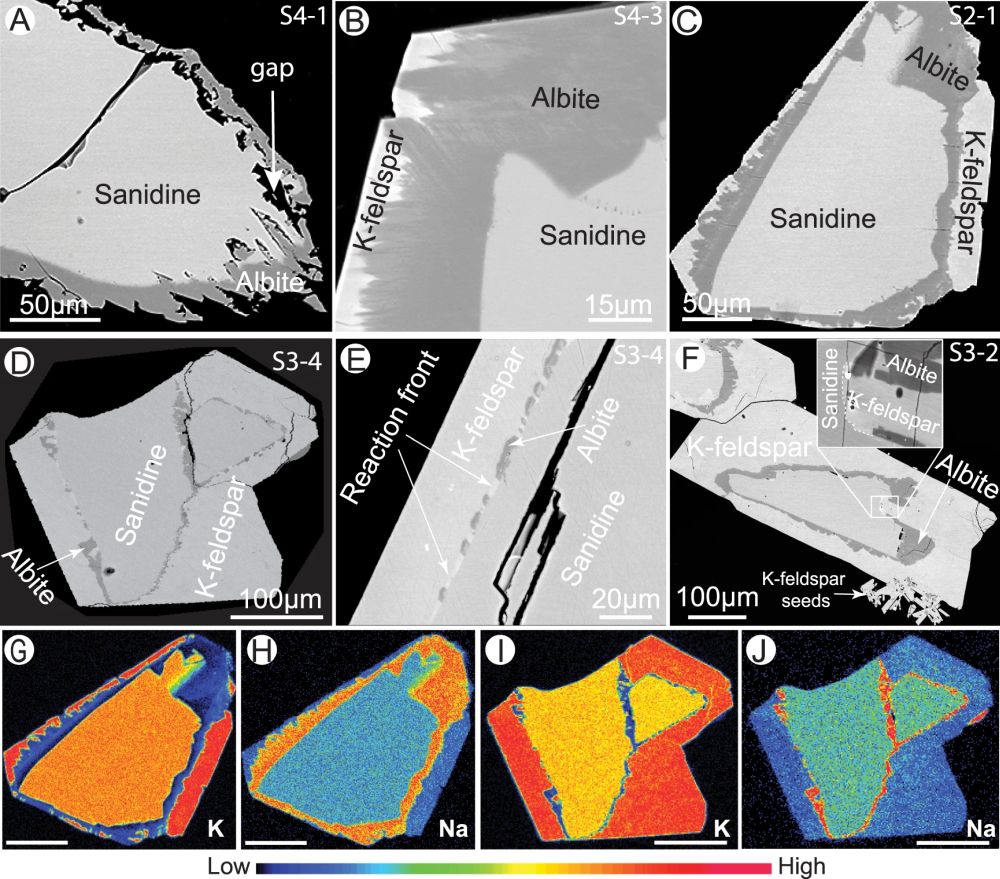
NC: 钾钠长石连续的钠-钾蚀变——受控于自我驱动的动力学过程(图)
钾钠长石 钠-钾蚀变 自我驱动 动力学过程
2021/9/30
坐标时间序列严密三维噪声模型建立方法
坐标时间序列 严密 三维噪声模型 方法
2019/9/20
积累多年的GPS基准站坐标时间序列被广泛应用 于大地测量学与地球动力学研究.实现坐标时间序列中 噪声与信号的有效分离并建立顾及不同分量噪声之间相 关性的严密三维噪声模型,有助于确定测站线性以及非 线性运动参数估值更加真实的不确定度.这对于精化速 度场、合理解释地壳形变特征、建立毫米级的地球参考框 架等研究具有重要的科学和现实意义.目前,虽然GPS 坐标时间序列噪声的研究成果丰富,但仍不能有效剔除 ...
利用地震资料、油气勘探资料分析了南海北部大陆边缘珠江口-琼东南新生代盆地断裂系统的时空差异及动力学成因机制.珠江口-琼东南盆地古近系裂陷构造层以NE向、近EW向基底正断层构成的伸展断裂系统的几何学、运动学沿着盆地走向有明显变化,盆地内部隐伏的区域性和局部的NW向断裂及相关构造变形带构成伸展断裂系统之间的构造变换带.在空间上,区域性的云开、松涛-松南等NW向构造变换带以西为NE-NEE向正断层构成的...
利用GPS和GRACE分析四川地表垂向位移变化
地表垂向位移 陆地水储量 连续运行参考站 时间序列分析 改进的总体平均经验模态分解
2017/10/17
陆地水储量的季节性变化是导致地表周期性负荷形变位移的主要因素,有效地剔除地表位移中的陆地水储量影响,是获取地壳构造垂向运动的必要过程.四川地处青藏高原东边缘,地形分区明显,境内以长江水系为主,水资源丰富,研究四川地区地表负荷形变位移,有助于分析陆地水储量的时空分布特性及地壳构造形变信息.本文利用研究区域内59个CORS站的GPS观测数据,计算了CORS站点的垂向位移,并将其与GRACE所得相应结果...
Dynamics of fluid and heat flow in a CO2-based injection-production geothermal system
Binary system CO2-water displacement Heterogeneity Preferential flow
2017/3/23
CO2 is now considered as a novel heat transmission fluid to extract geothermal energy. It can be used for both energy exploitation and CO2 geological sequestration. Here, a 3-D, “two-spot” pattern wel...
基于尺度空间技术的归一化Facet模型位场边界识别
边界识别 尺度空间函数 归一化Facet模型检测算子 位场
2017/2/27
边界识别是位场数据处理解释中的重要环节,传统边界识别方法通常不能均衡深、浅部地质体边界.基于尺度空间技术和归一化的Facet模型检测算子,本文开发了一种带通空间滤波和边缘检测相结合的边界识别方法,有效地提高位场数据边界识别的精度和可靠性.为了验证本文算法的有效性和稳定性,分析了不同尺度空间函数和检测算子对算法的影响,并且对比了传统边界识别方法的效果.理论模拟和实际数据分析表明,利用位场垂向二阶导数...
Antipersistent dynamics in short time scale variability of self-potential signals
Fractal propeties variogram analysis antipersistence self-potential signal earthquake prediction
2015/9/28
Time scale properties of self-potential signals are investigated through the analysis of the second order structure function (variogram), a powerful tool to investigate the spatial and temporal variab...
Mud volcanoes and microseepage: the forgotten geophysical components of atmospheric methane budget
methane lithosphere degassing mudvolcanoes greenhouse gas geodynamics
2015/9/10
Mud volcanoes and microseepage are two important natural sources of atmospheric methane, controlled by neotectonics
and seismicity. Petroleum and gas reservoirs are the deep sources, and faults and f...
Gas radon emission related to geodynamic activity on Mt. Etna
radon geodynamical precursor Mt. Etna
2015/9/10
We report preliminary observations on possible correlations between anomalies of subsoil radon concentration
and geodynamical events on Mt. Etna. In recent years several studies have been carried out...
ShakeMaps during the Emilia sequence
Ground motion Surveys measurements and monitoring Interments and techniques Seismological data
2015/8/26
ShakeMap is a software package that can be used to generate maps of ground shaking for various peak ground motion (PGM) parameters, including peak ground acceleration (PGA), peak ground velocity, and ...
ANNALS OF GEOPHYSICS:AD MAJORA
Annals of Geophysics Annali di Geofisica Impact factor Open source journal management and publishing Editorial changes
2015/8/17
Annals of Geophysics is a bimonthly international journal, which publishes scientific papers in the field of geophysics sensu lato. It derives from Annali di Geofisica, which commenced publication in ...
Ionospheric trends in Southern Hemisphere stations due to the increasing greenhouse gases concentration
Ionospheric trend EUV proxies Forecasts Dynamics
2015/8/14
The lower and middle atmosphere present long-term variations in temperature and other parameters linked to anthropogenic sources, such as the increase in greenhouse gases concentration since the start...
Representing life in the Earth system with soil microbial functional traits in the MIMICS model
functional traits Earth system
2015/8/6
Projecting biogeochemical responses to global environmental change requires multi-scaled perspectives that
consider organismal diversity, ecosystem processes, and
global fluxes.


